Places – Ireland
COUNTY ANTRIM (Aontroim)
Name: The old form of the name Antrim was Aentruibh, or Aentrebh, which probably means either one tribe or one habitation but this is not quite certain.

Size: Length of County Antrim, from The New Bridge over the Lagan, near Lisburn, to the Giant’s Causeway, 54-1/2 miles: breadth, from Island Magee to Toome on the Bann, 30 miles: area, 1191 square miles.
Surface: An almost uninterrupted succession of hills and uplands, a kind of irregular plateau, long and narrow, extends along the coast from Belfast Lough to Fair Head, with a narrow belt of well cultivated land between it and the sea.
COUNTY ARMAGH (Ard Macha)
Name: The name “Armagh” belongs to pagen times, and existed long before the time of St. Patrick. The oldest form is Ard-Macha, which means Macha’s height; this Macha being a semi-mythical heroine, the founder of the palace of Emania, 300 years B.C. The political significance of the area is doubtless one of the reasons why St Patrick made it the centre of his mission to convert the Irish in the fifth century. Armagh is still the ecclesiastical capital of both the Roman Catholic church and the Church of Ireland. The strong nationalistic traditions of South Armagh have become well known more recently.

Size: Length of County Armagh is 33 miles, north to south, and 21 miles, east to west, with a total area of 512-1/2 square miles.
Surface: The northern part – comprising the two baronies of Omeiland is flat, with much bog. The greater part of the rest of the county consists of gentle hills, for the most cultivated, or in pasture, with fertile valleys between.
County Armagh
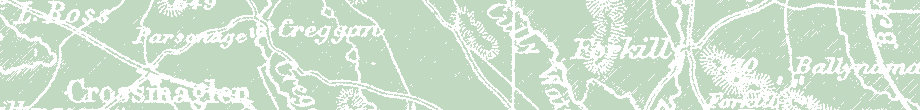
Creggan Parish
Map of Creggan Parish
Creggan Townlands
Creggan Parrish
Creggan Parrish Marriage Records
Creggan Parrish Baptism Records
Moybane Church
Crossmaglen
Crossmaglen
Crossmaglen Rangers
Crossmaglen Clock
Crossmaglen Conspiracy
Crossmaglen Streets
Crossmaglen Electricity
Galleries
 |
 |
|
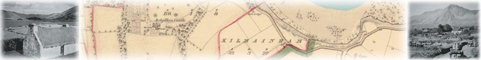
Full color, high quality maps are available for purchase through Past Homes. Past Homes offers a complete collection of the Ordinance Survey maps published between 1833 and 1846.
NEW! On-Line Map Browsing View the whole of Ireland and download the map you need with their new, easy to use, subscription-based tool. |
Gregoryology Facebook Group

 Chicagology
Gregoryology Facebook – Moved to Group
A Word From Our Sponsors